The resolution, sponsored by Commissioner Trey Goodwin, passed in a 4-1 vote, with Commissioner Paul Mixon dissenting, after commissioners rejected a proposed amendment that would have narrowed the ban’s application outside municipal boundaries.
The resolution targets two categories of devices: traffic infraction detectors, commonly known as red-light cameras, and speed detection systems deployed in school zones. According to county officials, the county does not currently have either type of camera on county rights of way, but staff have received requests from cities to install them there.
Goodwin said the issue was prompted in part by a ruling from Broward County Judge Steven DeLuca, who found the statutory framework governing traffic camera citations violates constitutional due process. DeLuca ruled in a case involving the city of Sunrise that the camera enforcement system improperly shifts the burden of proof onto the accused.
“The cameras don’t identify a person, they identify a vehicle,” Goodwin said. “Instead of the government bearing the burden to prove the driver, it puts the onus on the accused to prove their innocence, and that violates all fundamental principles of procedural due process.”
He said the ruling does not directly bind the county but called it a likely preview of more legal challenges to come. The resolution applies only to county rights of way and does not affect camera programs operated by municipalities on their own roads or rights of way.
The board also said the resolution is unrelated to license plate reader systems, commonly known as Flock cameras, used by the Okaloosa County Sheriff’s Office.
During public comment, speakers offered differing views.
Okaloosa resident Tim Bryant told the board he supported the ban, arguing camera-based enforcement bypasses Florida’s driver’s license point system, meaning dangerous drivers are not identified or removed from the road.
“The cameras don’t make us safer, they just collect money,” Bryant said.
Crestview Mayor JB Whitten, who voted against red-light cameras in the past, said he supports speed zone cameras in school zones despite his general opposition to traffic cameras. Whitten said he approved the speed cameras after data showed persistent speeding near schools.
Whitten said a 30-day test phase at a middle school on Old Bethel Road recorded 847 violations, including one driver clocked at 56 mph in a 20-mph zone. He also said 89.1% of drivers issued tickets last year received only one, suggesting the cameras were changing driving behavior.
“The intent is not to make money, the intent is to change driver’s patterns,” Whitten said. He urged the board to vote against the resolution or, at minimum, to table it until the state determines whether to appeal DeLuca’s ruling.
During deliberations, Mixon proposed a “friendly amendment” that would have restricted the ban to county roads outside municipal boundaries, arguing the county should respect the home rule authority of its nine municipalities. Goodwin rejected the amendment, saying the existing resolution already preserved city and state authority over their own roads.
“I will live and die on due process,” Goodwin said. “It is dangerous to use safety as an excuse to override our Constitution.”
The board also noted past incidents in which private vendors working for municipalities placed cameras on county rights of way without board approval, requiring Public Works staff to remove and store the equipment after vendors did not respond to removal requests.
“We need someone to step up and fight for this country,” Chico said. “That’s why I’m here.”
Chico was born at Naval Hospital Pensacola and traces his family’s roots in Northwest Florida to the 1800s, when his ancestors helped settle Walton County. His father attended the Naval Academy and flew as a Marine pilot. Chico followed him to Annapolis and later served as a Navy supply officer, with his first duty station back in Pensacola.
His naval career took him to the USS Iwo Jima, where he served as lead supply officer during the response to Hurricane Irma in 2017. He said his ship provided the only fresh water available in Key West for roughly half a day following the storm. His final assignment was as deputy staff logistics officer for Naval Training and Education Command, where he oversaw contracting, property management and hurricane evacuation.
Chico said his decision to enter the race traces directly to the rollout of Flock Safety, an AI-powered license plate reader system, in Pensacola late last year. After seeing news about the system, he said he called the mayor’s office three times and received no response.
“When I dug in, I realized this is a nationwide surveillance system,” he said. “There are between 56,000 and over 90,000 AI-powered cameras that scan all of our vehicles, every dent, every scratch, every unique identifier, and it reports to a national, centralized database where federal agencies, about 5,000 local police departments and state governments can pull that data and track everyone, without a warrant, without any oversight.”
Chico called the system a clear Fourth Amendment violation and said it represents the kind of government overreach he wants to take on in Washington. He has been sounding the alarm on the issue before announcing his candidacy, including a speech at the University of West Florida that he said drew thousands of attendees.
The issue has drawn attention across the region. Residents in Okaloosa County raised similar concerns when Flock cameras were introduced there, with records showing roughly 100 law enforcement agencies gained access to the system through the Okaloosa County Sheriff’s Office.
Chico’s answer to what he describes as an alliance between government surveillance and big tech is a federal Digital Bill of Rights, a legislative framework he says would extend constitutional protections into the digital age.
“Our founders were brilliant, but they could never envision AI, biometrics, facial recognition and modern surveillance,” he said. “We need to bridge that gap.”
He said the legislation would go beyond free speech protections to address how federal agencies collect and retain personal data. Among other things, he said Americans should have the right to know which federal databases hold their information, why it is being stored and for how long.
“How many databases have your information right now?” he asked. “You should have the right to request that — which federal databases is my information being stored in, why, and what’s the duration?”
“Whether it’s going after the right or going after the left, we shouldn’t be surveilling innocent American citizens unless they’re a real threat,” he said. “This is something Americans, whether on the right or the left, need to come together on.”
He extended his opposition to federal age verification laws being advanced by both parties, which would require social media platforms and websites to confirm users’ identities, in some cases through driver’s license uploads or facial scans. Chico called the measures a backdoor digital ID program that would hand government more censorship tools while delivering tech companies a database of verified users to monetize.
“It’s a holy alliance between big brother and big tech,” he said.
Chico has been sharp in his criticism of Patronis, who was elected to the seat in 2025 after serving as Florida’s Chief Financial Officer.
Chico accused the congressman of failing to pass legislation, alleged he voted to keep sexual harassment records in Congress sealed, a charge Chico said is funded by taxpayers, and faulted him for not securing military resources for the district.
He also criticized Patronis over a bill the congressman has proposed targeting social media liability protections under Section 230, which Chico characterized as an attempt to censor online speech. He has taken to calling the incumbent “Censorship Jimmy.”
On military matters, Chico pointed to reports of air wings departing Hurlburt Field as evidence that the district’s congressional representation has faltered on a core issue. He said the departure of military units translates directly to lost jobs and diminished economic opportunity throughout the region.
“District One relies on our military,” he said. “When we have military units leave the area, that’s taking away jobs, that’s taking away economic opportunity for everyone in the district.”
The Santa Rosa Press Gazette reached out to Patronis’ office for a statement on several accusations against him
In an email on March 18, Patronis only responded to claims about his bill to remove Section 230, saying, “Ending the special legal protections for Big Tech is a top priority. These companies are targeting our kids and making billions in the process. Children are losing their childhoods, and the tech cartels know it. We’ve heard from our own constituents’ stories of kids harming themselves, being exploited, and having their lives forever changed because of Big Tech.”
Navy veteran and Northwest Florida native Doug Chico is an American First candidate looking to win the Republican primary for Florida’s First Congressional District this August.
“Yet under current law, these companies can’t be held accountable,” Patronis added. “Social media may be free, but their business model depends on keeping kids hooked, and that’s wrong. My bill would repeal the special carve out that shields the tech giants.”
On foreign policy, Chico said he does not support what he described as unilateral, preemptive military strikes that fall outside the protection of clear American strategic interests. He acknowledged the Iranian government has been responsible, directly or indirectly, for the deaths of U.S. service members, but said military action requires a higher bar.
“I don’t support unilateral preemptive military strikes, especially if they don’t represent protecting our strategic interests,” he said.
He said he supports defending American allies when genuine U.S. interests are at stake but did not offer a blanket endorsement of NATO obligations, framing his foreign policy view around whether a given commitment serves the American people.
If elected, Chico said he would spend the final two years of the Trump administration focused on defending the Constitution and pushing back against what he called threats to civil liberties from both parties. He also called for a full immigration moratorium, saying unchecked both legal and illegal immigration needs to be brought under control.
Beyond surveillance policy, Chico’s platform centers on affordability and housing, federal infrastructure funding, protecting agricultural land from development, and addressing veteran homelessness.
On housing, he tied the affordability crisis to Federal Reserve monetary policy and government spending, arguing that inflation driven by deficit spending has robbed younger generations of purchasing power. He said he supports ending the Federal Reserve and called on Congress to prioritize affordable housing for millennials and Gen Z — a demographic he said he is uniquely positioned to speak to as the likely youngest candidate in the race.
“I can relate to the struggles of millennials and Gen Z in terms of affordability,” he said. “I have to feed my daughter. My food bill has increased dramatically. My cost of fuel has increased dramatically.”
“We need affordable housing for Gen Z and millennials,” he added. “I don’t want to sacrifice their futures just to please the donor class.”
On roads, Chico said federal dollars need to flow more directly to communities struggling with rapid growth. He cited a conversation with the Midway fire chief in Gulf Breeze, who told him his department cannot keep pace with population growth due to flat budgets — a problem Chico framed as a consequence of prioritizing foreign aid over domestic needs.
He also spoke to concerns from farmers and ranchers in the district, saying unchecked development threatens both the region’s agricultural heritage and its water supply. Chico said he supports halting new AI data centers in part to prevent further strain on the regional aquifer and electricity costs.
“We can’t allow this continuous development to eat up old Florida,” he said.
On veteran homelessness, Chico called it a moral failing and said housing and social services should prioritize Americans, particularly veterans, before other spending commitments.
He also said he would work to end civil asset forfeiture, calling the practice, in which law enforcement agencies can seize property from individuals without a criminal conviction, a form of government theft, citing Institute for Justice data showing $68 billion seized from American citizens and legal residents between 2000 and 2019.
On legislative process, Chico said Congress should abandon omnibus spending bills in favor of single-issue legislation, arguing the current practice allows both parties to attach what he called anti-freedom, unconstitutional provisions to must-pass bills. He also called for shortening the federal campaign cycle to reduce the influence of super PACs and corporate money in elections.
Chico described himself as his own largest donor by a wide margin, saying he has invested tens of thousands of dollars of personal funds into the campaign. He said that independence from outside donors is central to his pitch to voters.
He resists traditional political labels, saying he cannot be put in a box. He identifies as an “America First patriot” with libertarian leanings but said he is willing to cross the aisle when constituents would benefit.
“If a Democrat comes up with a good idea and it’s a net positive for most Americans, I’d be willing to support that bill,” he said.
Asked why voters should choose him in a crowded primary field, Chico leaned on roots and record.
“I’m not going to sell out to a corrupt political machine,” he said. “I’m a sixth-generation Northwest Florida family. I’m a former Navy officer. Unlike censorship Jimmy, my family’s actually from this area.”
The Republican primary for Florida’s 1st Congressional District is scheduled for August. The district, which covers Escambia, Santa Rosa, Okaloosa and Walton counties, has been reliably Republican for decades.
The item is on the board’s agenda for its March 24 meeting. The Community Project Funding Congressionally Directed Spending application was submitted to the U.S. Department of Transportation through the office of U.S. Rep. Jimmy Patronis. Because County Administrator John Hofstad submitted the application under an emergency provision before the meeting date, commissioners are being asked to ratify the submission retroactively.
The project targets the section of SR 85 running from Live Oak Church Road to PJ Adams Parkway, a stretch that has earned the nickname “Miracle Mile” for its role as the primary gateway connecting Eglin Air Force Base to north Okaloosa County.
The proposed improvements would include adding a northbound and southbound lane, multimodal and pedestrian facilities and stormwater management upgrades. County officials say the project would improve daily commutes for residents, reduce risks to military readiness and enhance hurricane evacuation capacity.
If the federal grant is awarded, the $5 million would offset local funding already committed through the county’s Infrastructure Surtax program. The overall project budget carries a match amount of $50 million, a combination of state and county funds, with $13 million designated as a cash match. The county has committed $10 million in direct funding and has transferred ownership of specific parcels valued at approximately $3 million to the Florida Department of Transportation for the project’s execution.
In a letter to Patronis dated March 16, Board Chairman Trey Goodwin outlined the urgency of the improvements and the county’s financial commitment to the corridor.
“The next critical step to improving traffic efficiency is to widen the lone roadway that feeds these segments,” Goodwin wrote, pointing to recent improvements including the widened PJ Adams Parkway and the forthcoming Southwest Crestview Bypass, expected to open this spring alongside a new FDOT interchange between PJ Adams Parkway and Interstate 10.
The board is also being asked to authorize Hofstad to serve as the Authorizing Official for the grant application, a designation that would be formally communicated to the U.S. Department of Transportation.
The project is managed through the county’s Public Works Roads and Bridges department under Director Scott Bitterman, with Roy Petrey serving as project manager.
The grant application carries a risk rating of “low” based on the county’s prior experience with federal funding programs, available staffing and the project’s alignment with the county’s strategic infrastructure priorities. The project would run from Oct. 1, 2026, through Sept. 30, 2027, if funding is received.
County officials note that the Miracle Mile widening represents one piece of a longer planned expansion of SR 85 from SR 123 to Interstate 10. Any award of grant funds would require separate board approval before the county enters into a formal agreement with the federal government.
Shoal River Middle School stands at 3200 E. Redstone Ave. and Riverside Elementary School stands just to the east, at 3400 E. Redstone Ave.
Once fully activated, the cameras will take photos and record videos of motor vehicles traveling more than 10 mph above the posted 20 mph speed limit in the school zone between 7:15 a.m. and 3:45 p.m. on weekdays.
During the city’s 30-day, state-required public awareness campaign that will include signs and community outreach, such speeders will receive a warning letter. After the campaign ends, they’ll be cited with a moving violation and given a $100 fine.
“The initial warning signs (letting drivers know about the cameras) have already been posted, and we believe that on Wednesday the actual cameras are going to go up,” Leavins said at the council meeting. “They’ll be calibrated, and by the end of the week you’ll start seeing the public notices (about the cameras) on social media and all of those different ways that we advertise things.”
Leavins
The 30-day warning period will run from Feb. 11 through Thursday, March 12, city officials said in a follow-up news release.
City officials are working with the Florida Department of Transportation and Okaloosa County to finalize permits for the installation of speed cameras for these other school zones: On State Road 85 in front of Crestview High School, on Old Bethel Road in front of Davidson Middle School, and on SR 85 near Northwood Elementary School and Richbourg School.
NovoaGlobal, of Orlando, is overseeing Crestview’s school zone speed camera program. Since early 2019, this company has managed the Hub City’s red-light camera program that cites drivers who drive north or south through red lights at the U.S. Highway 90-State Road 85 and SR 85-Redstone Avenue intersections.
In January 2025, NovoaGlobal on the city’s behalf conducted a three-day study to identify the number of drivers speeding through school zones while school was in session at CHS, Davidson Middle School, Northwood Elementary School and Richbourg School, and Shoal River Middle and Riverside Elementary schools. Among other findings, the study found that motor vehicles routinely traveled at least 11 mph above school zone speed limits during designated school hours.
A school crossing sign. (File photo)
According to city information, there are no upfront costs for equipment or installation of the school zone speed cameras. Like the red-light camera program, the school zone speed camera program is violator-funded, will issue notices of violation to vehicle owners, and will allow for administrative hearings before a code enforcement special magistrate.
Citations for speeding in a school zone do not add points to a driver’s license, according to information from NovoaGlobal.
Of the $100 fine assessed to violators, $60 will be used for local public safety initiatives, including speed detection systems in school zones, $12 will go toward school security and transportation initiatives, $5 will be used to recruit and retain crossing guards, and $23 will go to the state Department of Revenue.
“The goal is not to collect fines. The goal is to reduce speeds,” Crestview Police Chief Steve McCosker told the City Council early last year.
As of this afternoon, the jail housed a total of 740 inmates.
Since the new website deputed, members of the public, including the media, who seek to obtain a full day’s listing of booked inmates like they could on the old website have been directed by county officials to email a public records request to riskinfo@myokaloosa.com.
Unlike the old inmate search website, the new site, at https://okaloosacountyjail.myokaloosa.com/inmatelocator/, does not include an inmate’s home address and date of birth, nor does it list the law enforcement agency that made the arrest.
In addition, inmate photos on the new site are smaller and have a lower resolution than those that were posted on the old site.
The county DOC stopped using the old website at the end of January, county Public Information Officer Nick Tomecek said today.
“The technology for the former website was becoming obsolete and is no longer supported,” he said. “Some items (from the old website) are still migrating over to the new site.”
He did not know if the search by date capability would migrate over, or whether the inmate photos would be made larger and clearer.
Tomecek noted that, “The jail inmate search is one of the most popular things on (the county) website.”
The county jail is run by the county DOC and is under the purview of the County Commission, not the county Sheriff’s Office, he said, adding, “Who is booked in the jail is the county’s responsibility, not the Sheriff’s Office.”
S.O. Public Information Officer Michele Nicholson said she and other S.O. officials depend on the county’s inmate search website for much information.
When asked for her thoughts on the new website, Nicholson said, “We would assume, like most new systems, it’s a work in progress, and some of the initial issues that might be encountered will be remedied as the transition is smoothed out.”
District 1 County Commissioner Paul Mixon, whose district covers the northeastern quadrant of the county, could not immediately be reached for comment about the new website.
That surge in adoptions, she said, followed a November 2024 consult she had with the University of Florida Shelter Medicine team, which recommended Animal Services pursue a “barrier-free” adoption program.
“It’s been a year or more since we charged an adoption fee,” Healey said.
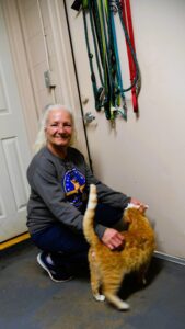
Animal Services Supervisor Katie Healey feeds treats to Happy Jack, which is a medium mixed breed and just over a year old. (Photo by Tony Judnich)
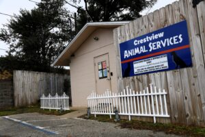
Animal Services, which is a division of the city Police Department, debuted in early 2022. Healey was the first employee of the division, which she created along with then-City Manager Tim Bolduc and other administrative staff after the city could not reach agreement with the Panhandle Animal Welfare Society on a new contract.
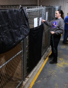
The Animal Services shelter stands at 715 N. Ferdon Blvd. The Animal Services division currently has a total of 48 animals – 19 cats and 29 dogs – in its care. Most of those animals are in foster homes in the community.
The shelter stands across State Road 85 from PNC Bank. (Photo by Tony Judnich)
“We rely heavily on foster homes,” Healey said, adding that Animal Services partners with about four to six people who regularly foster animals. “While we might not have all of those animals physically in our building, they’re in our care via foster families. We provide 24-hour support of our foster homes, so if you foster a pet for us, we provide all of the medical care and any supporting supplies (such as crates, food, and bedding) that they need. If somebody has a sick kitten in the middle of the night, they’re calling us, and we’re getting it transported to the emergency clinic.”
‘Community’ cats
Animal Services’ current budget of $596,000 is funded with city general fund dollars. In addition to Healey, the division’s employees consist of an animal control officer and three animal care technicians.
In 2025, Animal Services recorded a total of 357 pet adoptions, provided 148 animal rescue transfers, had 51 pets reunited with their families, and had 174 feral or “community” cats trapped, spayed/neutered, vaccinated and returned safely to the field, according to information from the division. Overall, the division had nearly 600 cats and dogs spayed or neutered last year.
Lead Animal Care Technician Cindy Hart, who has worked with Animal Services for about three years, pets Stomy the cat. Hart said the most rewarding part of her job is finding homes for the shelter animals. (Photo by Tony Judnich)
Animal Services implemented its “trap, neuter or spray, return,” or “TNR,” program for community cats within Crestview’s city limits when the division was established in 2022, Healey said.
“I do transports to Pensacola Humane Society at least twice a month, and the majority of those slots are for TNR cats,” she said, adding that the program has lowered the number of community cats in the area.
“It also decreases natural behavior by cats, which is typically what the nuisance is that people are calling and complaining about: Cats spray, they fight, they’re outside mating, they’re being obnoxious,” Healey said. “Some of those things would also dwindle down with the spaying and neutering of cats. (Overall), We’re putting a Band Aid on a bullet hole when it comes to (decreasing the number of community cats). The bottom line is, there’s thousands and thousands of cats that already exist in the environment, so the only way that we’re seeing fit to really attack the issue is by lowering the numbers with spay and neuter. That’s something we’re super passionate about.”
A heart for animals
Healey has worked in animal welfare for 10 years. She began her career at PAWS, which included a two-year stint as an animal control officer, and then moved to the Dallas area, where she worked as an animal care technician and then as an animal control officer for the city of Irving Police Department.
Healey later returned to Florida and employment with PAWS before going on to work for Saving With Soul Pet Rescue of Northwest Florida, Reichert Performance Horses in Holt, and Crestview Animal Services.
These five-month-old kittens, Petunia, top, and Venus, were brought to the Animal Services shelter on Tuesday. (Photo by Tony Judnich)
In her current job, “The most challenging thing all along has been creating a department while simultaneously running a department that has come with a lot of challenges,” she said. “But my biggest takeaway … when I worked in Irving, that was a huge, billion-dollar shelter. So I think that I had the mindset at one point that we needed some sort of big, beautiful thing to do great work. But having such a small facility and a small staff (in Crestview) has really been a blessing because I’m able to directly help people, like one-on-one, in the community, and we’re doing big things for such a small team. It makes me so proud to see the fruits of our efforts in the community.
“I want the community to trust us and see us as a resource, and not think of animal control as the antagonistic, scary dog catchers like they portray in movies. I want people to come here because they need help and they feel like we will help them. We want to obviously help and save as many animals as we possibly can.”
Healey closes Happy Jack’s pen after he’s placed back inside, while classical music or “enrichment noise” plays through a speaker. (Photo by Tony Judnich)
While most of Animal Services’ work is focused on animal care and welfare, the division’s overall job is really a people-first one, Healey said.
“We have to care about human equity as well,” she said. “It’s rewarding to watch a person who might come in here, who is homeless or about to be unhoused and needs supplies for their pet, and we help them and support them. And they come back a few times for some pet food, and we maybe connect them with a low-cost spay and neuter clinic. And then a few months later, they come back and maybe their puppy is now an adult, and it’s healthy and it’s fixed, and the person has a better living situation.
“And we were part of that story, and that’s important, that’s valuable.”
The Crestview Animal Services shelter is open from 11 a.m. to 5:30 p.m. Tuesday through Friday and 11 a.m. to 3 p.m. Saturday. The shelter accepts donated blankets, sheets, towels, pet toys, and wet and dry dog and cat food.
For more information, or to report an animal control issue, call (850) 682-2055. The Animal Services website is at https://www.cityofcrestview.org/697/Animal-Services.
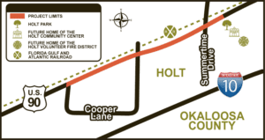
The Florida Department of Transportation’s preferred route for the proposed 2.4-mile paved path for pedestrians and cyclists runs along the south side of U.S. Highway 90, from Cooper Lane’s west leg to just east of Cooper Lane’s east leg, then continues along the north side of the highway before ending just east of Summertime Drive.
Project location map. (Credit: FDOT)
Max Cooper and his wife, Frances, were among a handful of Holt residents who attended the FDOT’s informational meeting about the “U.S. 90 Shared-Use Trail Project Development and Environment Study.” The meeting was held at First Baptist Church of Holt, 532 U.S. 90.
Max Cooper said Cooper Lane is named after his great uncle, John J. Cooper, who owned a pecan grove off Cooper Lane about a century ago.
“I don’t have a feeling on (the proposed shared-use path) one way or the other,” he said.
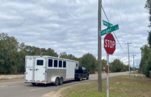
An eastward look at U.S. Highway 90 from the west leg of Cooper Lane in Holt. (Photo by Tony Judnich)
According to the FDOT, the intent of the PD&E study is to enhance multimodal infrastructure along U.S. 90 for the residents of Holt in order to improve bicycle and pedestrian safety, enhance trail connectivity, increase mobility and recreation, and promote economic development.
The planned trail, or path, would be part of the state’s Shared-Use Non-motorized Trail Program, which calls for a statewide system of interconnected and paved multi-use trails for pedestrians and bicyclists.
The PD&E study began in early 2024 and is set to end in mid-2026, FDOT spokeswoman Cassidy Taylor said. She said the design phase of the proposed path project is funded, but right-of-way acquisition and the construction phase are not.
The proposed project is not included in the FDOT’s current five-year workplan, FDOT officials said.
Max Cooper said hikers on the Florida Trail probably would be among the people who would use the potential path. Currently, a gap in the trail forces end-to-end trail hikers to walk along a stretch of U.S. 90 that passes through Holt.
Presented by Humane World for Animals and Maddie’s Fund, the award is a national honor and is given to emerging leaders in the animal welfare field to encourage continuing education and professional development, city officials said.
“We are ecstatic about all of the good work that Officer Healey has been doing in the community,” City Manager Jessica Leavins said at Monday’s City Council meeting. “We will recognize her in April, once she has that award in hand.”
Crestview Animal Services, which is a division of the city Police Department, debuted in early 2022. Healey was the first employee of the division, which she created along with then-City Manager Tim Bolduc and other administrative staff after the city decided not to renew services with the Panhandle Animal Welfare Society. The Animal Services shelter stands at 715 N. Ferdon Blvd.
Healey said she was shocked to win the Trailblazer award.
“I’m super-grateful to be recognized,” she said today, adding that she would not have won the award without the help of her team at Animal Services. “My agency is continuing to do things to provide more access for care.”
In 2025, Animal Services recorded 357 pet adoptions, provided 148 animal rescue transfers, had 51 pets reunited with their families, and had 174 community cats trapped, spayed/neutered, vaccinated and returned safely to the field, according to information from the division.
The Animal Care Expo that Healey plans to attend is set for April 7-10. At its meeting on Monday, the council approved a grant agreement with Humane World for Animals that includes the following benefits for Healey:
Coverage of the full conference registration fee and one Learning Lab ($385 value)
Hotel stay for up to four nights and round-trip airfare (up to $500).
Expo participation includes a “Leading for Change” workshop and a “CAWS Day” (Community Animal Welfare Service) event on April 7, according to city officials.
The commission unanimously approved moving ahead with this item at its Jan. 20 meeting. District 5 Commissioner Drew Palmer, whose district includes Destin, said he’s very much in favor of keeping parking free of charge for county residents who park at the various types of county recreation sites. His fellow commissioners agreed.
Palmer
The premise behind a pay-to-park system for non-county residents “would be to utilize the funding for capital improvements and maintenance of these park and recreational facilities and to potentially lower our park MSTU (Municipal Service Taxing Unit) rate,” county Facilities and Parks Director Jeff Peters said in a report to the commission.
Peters
Peters also made note of state legislators’ ongoing efforts to reduce property taxes, which local governments heavily rely on to pay general fund expenses. A potential constitutional amendment to lower property taxes might appear on November’s general election ballot.
“With potential funding changes on the horizon being discussed at the state legislature level, the county may need to pursue revenue efforts like (a pay-to-park system) as replacement funding for revenue shortfalls,” Peters said in his report. “Any such project will take some time to procure, initiate, and work out any bugs, so the sooner the start, the sooner such a system can be in place.”
Among other potential guidelines that the commission will finalize at a future meeting, the county’s pay-to-park system would seek to make revenue but have “reasonable” rates, allow customers to visit an app to look for available parking spaces, and possibly charge reduced fees or no fees during the winter season from November through February, according to county information.
In his report, Peters noted that the military charges $10 a day for parking at its beach park on Okaloosa Island, state and national parks within the county charge entry fees, and the Emerald Grand in Destin charges a flat $20 parking fee. He also said the Destin-Fort Walton Beach Airport, various private parking lots in the Destin area, and the city of Destin charge for parking.
Those and other pay-to-park systems will “allow the county to learn what works and what doesn’t in order to better pick an optimal system for the county’s needs,” Peters said.