Please ensure Javascript is enabled for purposes of website accessibility
Skip to main content
Advertisement

Okaloosa County inland areas added to wind advisory as Helene makes its way through Gulf

Okaloosa County has been added to a wind advisory by the National Weather Service.

On Wednesday morning, only the coastal areas of Okaloosa County were put under the wind advisory, but now the entire county has been added.

The path of Hurricane Helene, updated at 4 p.m. CT, still remains far to Okaloosa County’s east, aimed toward Florida’s big bend area.  Okaloosa/Walton County line

Here’s information on the wind advisory from NWS:

...WIND ADVISORY IN EFFECT FROM NOON THURSDAY TO MIDNIGHT CDT
THURSDAY NIGHT...

* WHAT...North winds 15 to 25 mph with gusts up to 40 mph expected
  becoming northwest.

* WHERE...In Alabama, Covington, Mobile Central, Baldwin
  Central, Mobile Coastal and Baldwin Coastal Counties. In
  Florida, Escambia Inland, Escambia Coastal, Santa Rosa Inland
  and Okaloosa Inland Counties.

* WHEN...From noon Thursday to midnight CDT Thursday night.

* IMPACTS...Gusty winds could blow around unsecured objects.
  Tree limbs could be blown down and a few power outages may
  result.

PRECAUTIONARY/PREPAREDNESS ACTIONS...

Use extra caution when driving, especially if operating a high
profile vehicle. Secure outdoor objects.

1 p.m. update: Okaloosa County schools are out Thursday; wind advisory for coastal areas of Okaloosa County

Sept. 25, 2024 | 1:34 p.m.

The National Hurricane Center released its 1 p.m. CT update on Hurricane Helene, providing the latest track for the storm, which remains relatively unchanged.

Helene is still projected to make landfall at 6 p.m. CT Thursday as a major hurricane.

Here are the important highlights for Okaloosa County:

  • The storm’s track still remains to Okaloosa County’s east, to the point that Okaloosa County is not under any watches or warnings. Tropical Storm Warnings go as far as the Okaloosa/Walton County line.
  • No watches or warnings were changed with the latest advisory.
  • Okaloosa County District Schools announced schools will be closed for Thursday. The district expects to resume normal operations on Friday.
  • Okaloosa County’s coastal areas are under a wind advisory from noon on Thursday until 6 a.m. on Friday, with northwest winds of 20 to 30 miles per hour and gusts of 45 miles per hour expected. The locations impacted include Bagdad, Gulf Breeze, Navarre, Destin, Eglin Air Force Base, Fort Walton Beach, Niceville, Seminole, Valparaiso and Wright.
  • Current estimates from the National Weather Service predict 2 to 4 inches of rain for Okaloosa County.
  • The city of Crestview has asked all contractors within the city limits to ensure jobsites are picked up and that items are secure so that they won’t get blown around when the storm hits. “Please secure any items that could become windborne debris and verify that erosion control measures are properly implemented in anticipation of heavy rainfall,” the city said in a Facebook post.

Florida braces for powerful Helene

By Jim Turner

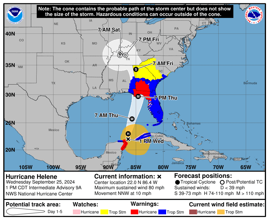
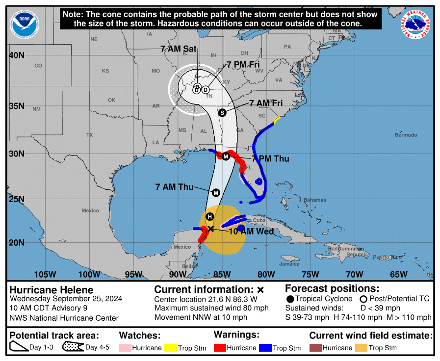
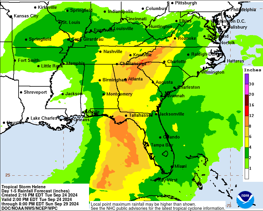
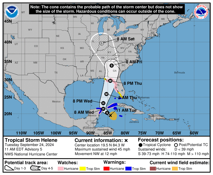
Models indicate Helene will make landfall Thursday night as a major hurricane in the Big Bend region, which continues to recover from Hurricane Debby in early August and Hurricane Idalia in August 2023. Models also indicate storm-force winds could stretch up to 200 miles from the center.

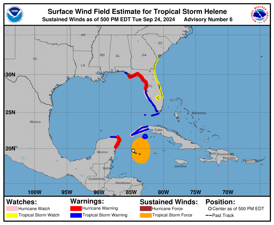
A hurricane warning was in effect from the Anclote River in the Pasco County area to Mexico Beach in Bay County.

Expected to rapidly intensify in the warm waters of the eastern Gulf of Mexico, Helene is projected to create storm surge throughout Florida’s Gulf Coast. A storm-surge warning was in effect from Flamingo in Monroe County to Indian Pass in Gulf County.

“It is anticipated that there is going to be power outages,” DeSantis said Wednesday during an appearance at TECO Energy East Hillsborough in Tampa. “So folks have an opportunity to plan for that now. You still have time to make the preparations and put your plan in place today. But that time is running out.”

President Joe Biden on Tuesday approved an emergency declaration that authorizes federal money to help state and local efforts. It also gave authority to the Federal Emergency Management Agency to coordinate disaster relief. Earlier, DeSantis declared a state of emergency for 61 of Florida’s 67 counties.

About 18,000 utility workers are in position to help with restoring power, and DeSantis said that number will increase.

The Florida Municipal Electric Association said Wednesday its restoration workforce of 1,200 is being bolstered by more than 350 workers from nine states. Power outages, for example, could be a major issue in Tallahassee, which is served by a municipal utility.

Duke Energy Florida said it was readying 8,000 workers to respond to the storm. Also, crew members were coming from Duke Energy’s operations in Kentucky, Ohio and Indiana.

The Florida Department of Transportation lifted weight restrictions for utility and emergency response vehicles.

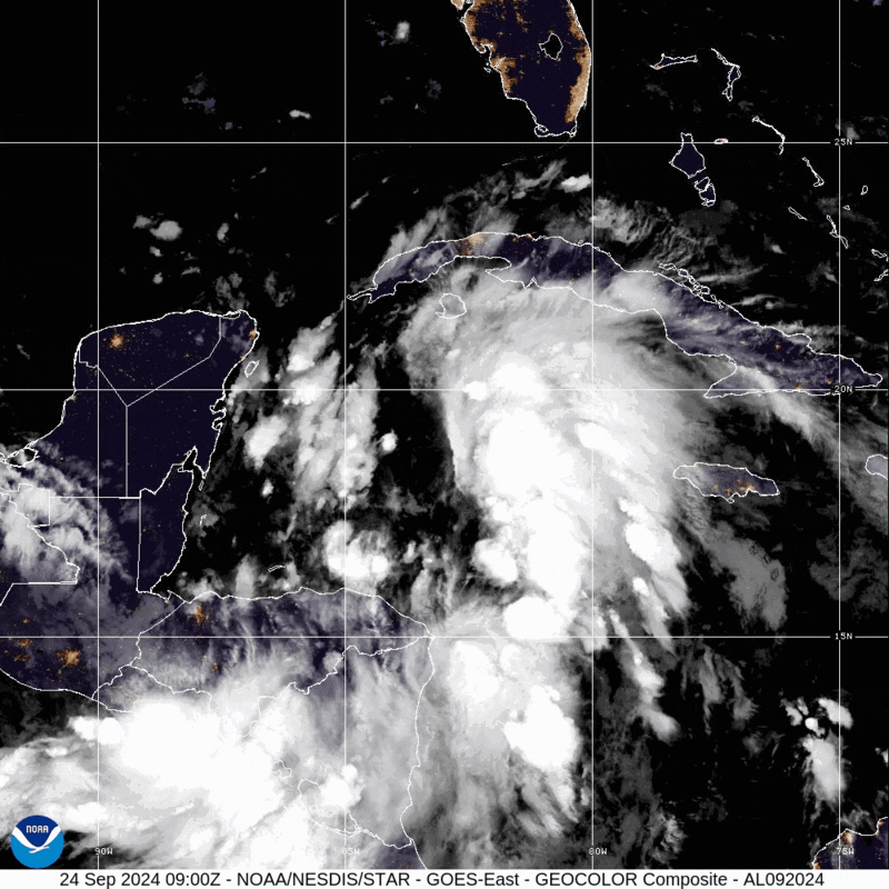
As of Wednesday morning, state Division of Emergency Management Kevin Guthrie said Helene’s outer bands were already being felt across South Florida.

“Please do not focus on the forecast cone,” Guthrie said. “The hazards from this large storm, over 250 miles from the center, will be far, far reaching.”

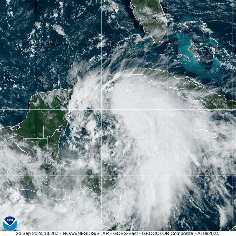
Wednesday morning, Helene was off the northeastern coast of the Yucatan Peninsula, packing maximum sustained winds of 80 mph and moving north-northwest at 10 mph.

The meteorological company AccuWeather warned Helene will create “life-threatening impacts” hundreds of miles away from where it makes landfall.

“The combination of deep warm water (ocean heat content) and low disruptive breezes (wind shear), should assist in rapid strengthening when Helene moves over the Gulf of Mexico from Wednesday to Thursday,” AccuWeather Chief On-Air Meteorologist Bernie Rayno said in a statement.

AccuWeather expects Helene to make landfall late Thursday in the eastern part of the Panhandle as a Category 3 hurricane, which indicates sustained winds of 111 mph to 129 mph on the Saffir-Simpson Hurricane Wind Scale.

The storm could tip into Category 4 status, which would be 130 mph to 156 mph, while over the Gulf of Mexico, according to AccuWeather.

The National Weather Service said the storm has the potential to bring storm surge topping 15 feet near where the eye comes ashore and east of that area.

The risk of tornados is expected to begin Wednesday night.

The Port of Key West was closed Wednesday morning, while vessel movement was stopped at the Port of St. Petersburg, Port Manatee and Port Tampa Bay.

A hurricane watch was in place from Englewood, at the Charlotte and Sarasota county line, the Anclote River.

A tropical storm warning was in place for the Dry Tortugas, the Florida Keys, the west coast from Flamingo to Anclote River, the Panhandle coast from Mexico Beach to the border of Bay and Walton counties and on Florida’s East Coast.

10 a.m. Helene update: Tropical storm warning extended to Okaloosa/Walton County line

Sept. 25, 2024 | 10:43 a.m.

The National Hurricane Center provided its latest update on now Hurricane Helene on Wednesday morning at 10 a.m.

Little change is shown in the path of the storm, which still has the eye going east of Santa Rosa County.

However, the storm has strengthened, now becoming hurricane with sustained winds of about 80 miles per hour, according to the National Weather Service. The Tropical Storm warning was extended west to the Okaloosa County/Walton County line.

The storm is expected to make landfall in Florida’s big bend region around 7 p.m. on Thursday.

Helene expected to become hurricane by Wednesday evening

Sept. 24, 2024 | 10:22 p.m.

The National Hurricane Center published its final update of the day at 10 p.m., with little change in the projected path for Tropical Storm Helene.

Here’s the quick notes, for anyone playing catch up at this point:

  • The storm is still just southeast of the Yucatan Peninsula, but it is expected to become a hurricane by Wednesday evening as it begins its movement into and through the Gulf of Mexico.
  • Helene’s eye is expected to hit Florida’s “big bend” area as a major hurricane.
  • Tropical Storm and Hurricane warnings have been issued for much of Florida’s coast, but Okaloosa County is not included.
  • For what it’s worth, the projected time of landfall has moved up to 6 p.m. CT on Thursday. Earlier today, it was 7 p.m. CT. However, it’s important to note that the exact timing is still up in the air at this point.
  • Helene is expected to move quickly after making landfall. By Friday at 6 a.m. CT, the eye is projected to be in northwest Georgia.

What it means for Okaloosa County:

  • The storm remains to our east and current forecasting has Okaloosa County receiving 4 inches of rain.
  • If the current forecast remains intact, the worst of the conditions would be far east of Okaloosa County.
  • Stay weather aware, just in case of changes in the forecast in the final few days.

4 p.m. update: Helene’s path remains relatively unchanged as hurricane warnings issued to our east

Sept. 24, 2024 | 4 p.m.

The 4 p.m. update from the National Hurricane Center on Tropical Storm Helene showed little change in the expected path of the storm, which is still trending toward Florida’s “big bend.”

The storm’s eye remains east of Santa Rosa County. The storm is expected to make landfall Thursday night, with the exact timing still to be determined.

Here’s part of the latest advisory from the National Hurricane Center.

At 500 PM EDT (2100 UTC), the center of Tropical Storm Helene was
located near latitude 19.7 North, longitude 84.7 West.  Helene is
moving toward the west-northwest near 12 mph (19 km/h).  A turn 
toward the northwest is expected tonight, followed by a general 
northward motion beginning on Wednesday and continuing through 
Friday.  On the forecast track, the center of Helene will pass near 
the northeastern coast of the Yucatan Peninsula on Wednesday, move 
across the eastern Gulf of Mexico on Wednesday and Thursday, and 
reach the Big Bend coast of Florida late Thursday.

Maximum sustained winds have increased to near 50 mph (85 km/h) 
with higher gusts.  Additional strengthening is forecast, and 
Helene is expected to become a hurricane on Wednesday.  The storm 
is forecast to rapidly strengthen over the eastern Gulf of Mexico 
and become a major hurricane on Thursday.

Tropical-storm-force winds extend outward up to 175 miles (280 km)
to the east of the center.


Hurricane warnings and tropical storm warnings have been issued for areas to our east.

SUMMARY OF WATCHES AND WARNINGS IN EFFECT:

A Storm Surge Warning is in effect for...
* Indian Pass southward to Flamingo
* Tampa Bay
* Charlotte Harbor

A Hurricane Warning is in effect for...
* Anclote River to Mexico Beach, Florida
* Cabo Catoche to Tulum, Mexico

A Hurricane Watch is in effect for...
* Cuban province of Pinar del Rio
* Englewood to Anclote River, including Tampa Bay

A Tropical Storm Warning is in effect for...
* Dry Tortugas
* Lower and Middle Florida Keys west of the Channel 5 Bridge
* Flamingo to Anclote River, including Tampa Bay
* Rio Lagartos to Tulum, Mexico
* Cuban provinces of Artemisa, Pinar del Rio, and the Isle of Youth

A Tropical Storm Watch is in effect for...
* Lake Okeechobee
* Palm Beach/Martin County Line northward to the Savannah River

Tropical Storm Helene forms in the Caribbean Sea

Sept. 24, 2024 | 12:10 p.m.

No longer Projected Tropical Cyclone Nine, Tropical Storm Helene has formed over the northwestern Caribbean Sea.

The projected path of the storm still shows it going east of Okaloosa County, hitting in Florida’s “big bend,” making landfall as a major hurricane at 7 p.m. CT on Thursday.

Current rainfall projections from the National Hurricane Center show Santa Rosa County receiving somewhere between 2 and 4 inches of rain.

The NHC expects the storm to strengthen as it makes its way through the Caribbean Sea. Here’s information from their latest advisory:

A northward to north-northeastward motion at a faster forward speed 
is expected on Wednesday and Thursday.  On the forecast track, the 
center of Helene will move across the far northwestern Caribbean 
Sea through tonight, and then move across the eastern Gulf of 
Mexico Wednesday and Thursday, potentially reaching the Gulf coast 
of Florida late Thursday.

Data from an Air Force Reserve Hurricane Hunter aircraft indicate 
that the system has acquired a well-defined center of circulation, 
and maximum sustained winds have increased to near 45 mph (75 km/h) 
with higher gusts.  Additional strengthening is forecast, and 
Helene is expected to become a hurricane on Wednesday.  Continued 
strengthening is anticipated after that time, and Helene could 
become a major hurricane on Thursday.


Florida readies for ‘dangerous storm’

By Jim Turner

Gov. Ron DeSantis noted some uncertainty in the forecast for what is expected to become Hurricane Helene. He expanded a state of emergency to 61 of the state’s 67 counties, with only some counties in Southeast Florida excluded. DeSantis, who declared a state of emergency in 41 counties Monday, also requested a federal emergency declaration in advance of the storm making landfall.

“I think the fact that this would be forecasted as a major (hurricane) at this point without formation, shows that this has a potential to be a really, really significant storm,” DeSantis said during a news conference Tuesday morning at the state Emergency Operations Center.

The storm was on a track to make landfall in North Florida.

“The Big Bend and Panhandle should be especially prepared for a direct impact,” DeSantis said.

Both areas are in different stages of recovery from hurricanes. Hurricane Michael caused massive damage in the Panhandle in 2018 after making landfall near Mexico Beach with 160 mph sustained winds. Hurricane Idalia in 2023 and Hurricane Debby this year made landfall in Taylor County in the Big Bend region before causing damage across North Florida.

DeSantis said impacts could be felt 100 miles to 200 miles from the center of what is expected to be “a potentially very dangerous storm.”

With power outages anticipated from what was being called Potential Tropical Cyclone 9, Duke Energy Florida said it was preparing for the aftermath.

“While Potential Tropical Cyclone 9’s path and intensity are still uncertain, Duke Energy Florida is preparing to respond as quickly as possible should our customers experience any disruptions in service,” Melissa Seixas, Duke Energy Florida state president, said in a prepared statement. “We strongly encourage our customers to plan ahead for the potential impacts of the storm and use this time to ensure they have all the supplies they need to stay safe and informed.”

DeSantis said about 18,000 utility line workers are being pre-positioned. His executive order also activated 3,000 members of the Florida National Guard and the Florida State Guard.

“We are amassing significant resources to move in and restore power,” DeSantis said.

Florida Division of Emergency Executive Director Kevin Guthrie said he expects local evacuation decisions to be made Wednesday and urged Floridians to finalize preparation plans, including a full tank of gas and seven days of food and water.

The National Hurricane Center on Tuesday gave the system a “near 100 percent” chance of formation in the next 48 hours. It said Southwest Florida likely will start to feel winds from the system Wednesday as it moves north in the gulf.

“The system is expected to intensify into a major hurricane before it approaches the northeastern Gulf Coast on Thursday, and the potential for life-threatening storm surge and damaging hurricane-force winds along the coast of the Florida Panhandle and the Florida west Gulf Coast is increasing,” the hurricane center said in a Tuesday morning advisory.

With maximum sustained winds of 35 mph, the center of the system Tuesday morning was about 205 miles south-southeast of the western tip of Cuba.

A hurricane watch was in place from Englewood, at the border of Charlotte and Sarasota counties, to Indian Pass in Gulf County.

Storm surge watches were in place from Indian Pass to Flamingo, in Monroe County.

Storm surge is expected to top five feet in Tampa Bay. It is expected to reach more than 10 feet from the Ochlockonee River, which empties into the gulf south of Tallahassee, to the Chassahowitzka River near Crystal River.

Early morning update shrinks cone of uncertainty, storm still east of Okaloosa County

The storm is expected to hit Florida’s big bend area, where it’s projected to be a major hurricane.

Here’s the latest information in the National Hurricane Center’s advisory, including where hurricane and tropical storm watches have been issued (which again doesn’t include Okaloosa County):

A Storm Surge Watch has been issued from Indian Pass Florida 
southward to Bonita Beach Florida, including Tampa Bay and 
Charlotte Harbor.

A Hurricane Watch has been issued for the Gulf Coast of Florida 
from Englewood northward and westward to Indian Pass, including 
Tampa Bay.

A Tropical Storm Watch has been issued for the Gulf Coast of 
Florida from Indian Pass to the Walton/Bay County Line and from 
north of Bonita Beach to south of Englewood.

SUMMARY OF WATCHES AND WARNINGS IN EFFECT:

A Storm Surge Watch is in effect for...
* Indian Pass southward to Flamingo
* Tampa Bay
* Charlotte Harbor

A Hurricane Watch is in effect for...
* Cabo Catoche to Tulum, Mexico
* Cuban province of Pinar del Rio
* Englewood to Indian Pass
* Tampa Bay

A Tropical Storm Warning is in effect for...
* Grand Cayman
* Rio Lagartos to Tulum, Mexico
* Cuban provinces of Artemisa, and Pinar del Rio, and the Isle of
Youth

A Tropical Storm Watch is in effect for...
* Dry Tortugas
* Lower Keys west of the Seven Mile Bridge
* Flamingo to south of Englewood
* West of Indian Pass to Walton Bay County line

A Storm Surge Watch means there is a possibility of life-
threatening inundation, from rising water moving inland from the
coastline, in the indicated locations during the next 48 hours.
For a depiction of areas at risk, please see the National Weather
Service Storm Surge Watch/Warning Graphic, available at
hurricanes.gov.

A Tropical Storm Warning means that tropical storm conditions are
expected somewhere within the warning area, in this case within
the next 24 to 36 hours.

A Hurricane Watch means that hurricane conditions are possible
within the watch area.  A watch is typically issued 48 hours
before the anticipated first occurrence of tropical-storm-force
winds, conditions that make outside preparations difficult or
dangerous.

A Tropical Storm Watch means that tropical storm conditions are
possible within the watch area, generally within 48 hours.

Interests elsewhere along the northeastern Gulf Coast, including the 
Florida Panhandle and the Florida west Gulf coast, should monitor 
the progress of this system.  Additional watches or warnings will 
likely be required today.


7 p.m. update: Latest advisory provides latest track of Potential Tropical Cyclone Nine

The path still takes it toward Florida’s “big bend,” meaning the eye is projected to land east of Okaloosa County.  However, much uncertainty remains about the storm’s future path. It’s projected landfall is Thursday afternoon.

The National Hurricane Center said the following as part of its advisory:

“Interests along the northeastern Gulf Coast, including the Florida Panhandle and the Florida west coast, should monitor the progress of this system. Additional watches or warnings will likely be required tonight and Tuesday.”

error: Content is protected !!