Please ensure Javascript is enabled for purposes of website accessibility
Skip to main content
Advertisement

Florida starts recovery after monster storm

By Jim Turner

State Division of Emergency Management Director Kevin Guthrie implored people not involved in recovery efforts to stay off the roads as authorities conducted search-and-rescue efforts amid debris and dissipating storm surge.

“Please do not go out and visit the impacted areas,” Guthrie said Friday morning at the state Emergency Operations Center. “We have over 1,500 search and rescue personnel in the highly impacted areas right now. Do not get in their way. We need you to stay off the roads and get out of our way so that we could go do our jobs.”

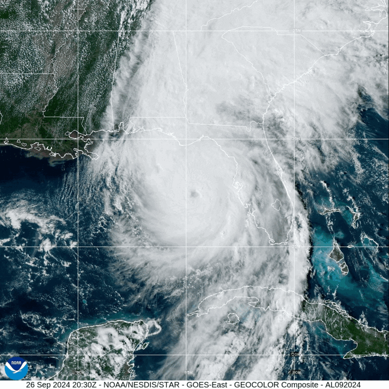
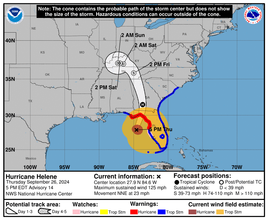
Packing 140 mph winds, Helene swept through North Florida after surging onto land about 11:10 p.m. Thursday east of the mouth of the Aucilla River, about 10 miles from the Taylor County community of Perry. But storm surge from the massive storm also caused damage up and down the state’s Gulf Coast.

Hillsborough County Emergency Management Director Timothy Dudley said Friday morning many people remained in areas hit by storm surge after they did not leave as Helene moved north parallel to the coast.

“Our rescue teams are currently working hard in the field to save lives,” Dudley said. “Unfortunately, many people did not heed our order to evacuate Zone A, and they have left themselves in a very dangerous situation. As forecasted, the storm surge reached 5 to 8 feet at various locations throughout Hillsborough County, and the danger is not over yet.”

Authorities said two deaths had been attributed to the storm Friday morning. Also, the storm had left more than 1.24 million utility customers without electricity.

Power outages remained close to 100 percent in Suwanee, Taylor, Hamilton, Madison, Dixie and Columbia counties, which were directly in Helene’s path. The storm also left people in the dark in numerous other areas of the state.

For example, Duke Energy Florida said that as of 7:30 a.m., it had restored power to nearly 198,000 customers, but more than 402,000 still had outages.

“Our crews worked through the night to assess the immense damage caused by Hurricane Helene and get the lights back on where conditions allowed,” Todd Fountain, Duke Energy Florida storm director, said in a prepared statement. “We’ve made significant progress over the last 24 hours, but we still have a lot of work ahead of us.”

Similarly, Florida Power & Light said that as of 6 a.m., 214,000 of its customers did not have power. Florida Municipal Electric Association Executive Director Amy Zubaly said 235,839 municipal-utility customers remained without power as of 9 a.m.

Helene was the third hurricane to make landfall in rural Taylor County in a little more than a year, after Hurricane Idalia in August 2023 and Hurricane Debby last month.

During a Friday morning news conference, Gov. Ron DeSantis worried that there might be a “sense of trauma” for communities that also have had to rebuild after the two earlier storms.

“I think there’s a demoralization,” DeSantis said. “It’s like, ‘OK, we worked all this, and then now we could potentially be worse off than we were even before.’”

But DeSantis added the state will assist people in what were already designated as “fiscally constrained” rural communities.

“We’re going to have support there,” DeSantis said. “It’s not easy, but we’ll get through it.”

Interstate 10 and Interstate 75 were open Friday morning. Bridge inspections were underway along the Gulf Coast, where storm surge closed a number of closings.

Florida Department of Transportation Secretary Jared Perdue said “cut and toss” efforts continued to clear debris from roads.

“There is a lot of vegetative debris. There’s a lot of debris in the roads,” Perdue said. “Trees can be wrapped in power lines. Please do not get out there and start trying to do things on your own.”

Tampa International Airport reopened Friday morning. Also, airports in Tallahassee, Gainesville, Lakeland and St. Petersburg-Clearwater were expected to open.

Perdue said Port Tampa, which was among the state’s seaports that experienced monster storm surge, plans to “open as quickly as possible.”

“They have to inspect the channel, but their fuel operation will be back up and running within the next few hours,” Perdue said.

DeSantis said the fatalities attributed to Helene involved a motorist whose vehicle was hit by a highway sign in Tampa and a Dixie County resident who was inside a home hit by a fallen tree.

Helene lashes the South with wind and sheets of rain. Millions are without power

By Stephen Smith, Kate Payne and Heather Hollingsworth
Associated Press

CRAWFORDVILLE, Fla. (AP) — Hurricane Helene roared ashore as a powerful Category 4 storm in a sparsely populated region of Florida, peeling the siding from buildings, trapping residents in rising floodwaters and knocking out power to millions of customers. At least five people were reported dead.

The storm made landfall late Thursday with maximum sustained winds of 140 mph (225 kph) in the rural Big Bend area, home to fishing villages and vacation hideaways where Florida’s Panhandle and peninsula meet.

Video on social media sites showed sheets of rain coming down and siding coming off buildings in Perry, Florida, near where the storm arrived. One local news station showed a home that was overturned.

First responders were out in boats early Friday to rescue people trapped by flooding in Citrus County, some 120 miles (193 kilometers) south of Perry.

“If you are trapped and need help please call for rescuers – DO NOT TRY TO TREAD FLOODWATERS YOURSELF,” the sheriff’s office warned in a Facebook post. Authorities said the water could contain live wires, sewage, sharp objects and other debris.

Nearly 4 million homes and businesses were without power Friday morning in Florida, Georgia and South Carolina, according to poweroutage.us, which tracks utility reports.

One person was killed in Florida when a sign fell on their car, and two people were reported killed in a possible tornado in south Georgia as the storm approached. Trees that toppled onto homes were blamed for deaths in Charlotte, North Carolina, and Anderson County, South Carolina.

The hurricane came ashore near the mouth of the Aucilla River on Florida’s Gulf Coast. That location was only about 20 miles (32 kilometers) northwest of where Hurricane Idalia hit last year at nearly the same ferocity and caused widespread damage.

As the hurricane’s eye passed near Valdosta, Georgia, a city of 55,000 near the Florida line, dozens of people huddled early Friday in a darkened hotel lobby. The wind whistled and howled outside.

Electricity was out, with hallway emergency lights, flashlights and cellphones providing the only illumination. Water dripped from light fixtures in the lobby dining area, and roof debris fell to the ground outside.

Fermin Herrera, 20, his wife and their 2-month-old daughter left their room on the top floor of the hotel, where they took shelter because they were concerned about trees falling on their Valdosta home.

“We heard some rumbling,” said Herrera, cradling the sleeping baby in a downstairs hallway. “We didn’t see anything at first. After a while the intensity picked up. It looked like a gutter that was banging against our window. So we made a decision to leave.”

In Thomas County, Georgia, where residents had been under a curfew, the sheriff’s office said it was extended until noon Friday.

“This curfew helps protect first responders and citizens of our community as conditions are still very hazardous. Please shelter in place,” the office posted online.

Helene is the third storm to strike the city in just over a year. Tropical Storm Debby blacked out power to thousands in August, while Hurricane Idalia damaged an estimated 1,000 homes in Valdosta and surrounding Lowndes County a year ago.

“I feel like a lot of us know what to do now,” Herrera said. “We’ve seen some storms and grown some thicker skins.”

Soon after it crossed over land, Helene weakened to a tropical storm, with its maximum sustained winds falling to 70 mph (110 kph). At 5 a.m., the storm was about 40 miles (65 kilometers) east of Macon, Georgia, and about 100 miles (165 kilometers) southeast of Atlanta, moving north at 30 mph (48 kph), the National Hurricane Center in Miami reported.

Forecasters expected the system to continue weakening as it moves into Tennessee and Kentucky and drops heavy rain over the Appalachian Mountains, with the risk of mudslides and flash flooding.

Even before landfall, the storm’s wrath was felt widely, with sustained tropical storm-force winds and hurricane-force gusts along Florida’s west coast. Water lapped over a road in Siesta Key near Sarasota and covered some intersections in St. Pete Beach. Lumber and other debris from a fire in Cedar Key a week ago crashed ashore in the rising water.

Beyond Florida, up to 10 inches (25 centimeters) of rain had fallen in the North Carolina mountains, with up to 14 inches (36 centimeters) more possible before the deluge ends, setting the stage for flooding that forecasters warned could be worse than anything seen in the past century.

“Please write your name, birthday, and important information on your arm or leg in a PERMANENT MARKER so that you can be identified and family notified,” the sheriff’s office in mostly rural Taylor County warned those who chose not to evacuate in a Facebook post, the dire advice similar to what other officials have dolled out during past hurricanes.

School districts and multiple universities canceled classes. Airports in Tampa, Tallahassee and Clearwater were closed Thursday, while cancellations were widespread elsewhere in Florida and beyond.

A day before hitting the U.S., Helene swamped parts of Mexico’s Yucatan Peninsula, flooding streets and toppling trees as it brushed the resort city of Cancun and passed offshore. In western Cuba, Helene knocked out power to more than 200,000 homes and businesses as it brushed past the island.

At one point, forecasters feared that hurricane conditions could extend as far as 100 miles (160 kilometers) north of the Georgia-Florida line. Overnight curfews were imposed in many cities and counties in south Georgia.

“This is one of the biggest storms we’ve ever had,” Georgia Gov. Brian Kemp said.

For Atlanta, Helene could be the worst strike on a major Southern inland city in 35 years, said University of Georgia meteorology professor Marshall Shepherd.

Helene is the eighth named storm of the Atlantic hurricane season, which began June 1. The National Oceanic and Atmospheric Administration has predicted an above-average Atlantic hurricane season this year because of record-warm ocean temperatures.

Three deaths attributed to Hurricane Helene

Sept. 26, 2024 | 11 p.m.

Three people have died from the impacts of Hurricane Helene, according to a report from the Associated Press.

Florida Gov. Ron DeSantis said one of the deaths was in Tampa, where a person driving across Interstate 4 was killed when a sign fell on their vehicle. DeSantis said people need to hunker down until the storm passes.

Two people were also killed in a possible tornado in Alamo, Georgia, according to the Associated Press.

DeSantis’ full press conference is below:

Hurricane Helene makes landfall near Perry

Sept. 26, 2024 | 10:24 p.m.

The National Hurricane Center said that at 10:20 p.m. CT, Hurricane Helene made landfall as a category four hurricane in Florida’s Big Bend region.

The eye was about 10 miles west-southwest of Perry. The maximum sustained winds of the storm were 140 miles per hour.

Okaloosa schools open Friday, with Eglin Elementary the lone exception

Sept. 26, 2024 | 6:54 p.m.

The Okaloosa County School District will be open on Friday, Sept. 27, with the one exception being Eglin Elementary School.

“The Okaloosa County School District is pleased to confirm that all schools will be open and operating as scheduled tomorrow, Friday, September 27, following a comprehensive update with Okaloosa County Public Safety Director Patrick Maddox,” a press release from the school district said. “We are grateful that Okaloosa County avoided the worst of Hurricane Helene’s impact, and our thoughts remain with the counties more severely affected by Hurricane Helene.”

The district then confirmed that Eglin Elementary would actually be closed.

“The Okaloosa County School District would like to provide an important update regarding Eglin Elementary,” a second press release said. “At the direction of Eglin Air Force Base leadership, Eglin Elementary will be closed tomorrow, Friday, September 27th, as the base will not open until 11:00 a.m. This decision follows the base’s standard post-storm safety protocol to ensure a secure environment for all operations.”

Hurricane Helene nears landfall, likely as a category four storm

Hurricane Helene is nearing landfall in Florida’s big bend area as a category three storm. The 4 p.m. update from the National Hurricane Center notes that Helene is likely to make landfall as a category four hurricane.

Maximum sustained winds were at 125 miles per hour, with higher gusts. To reach category four status, Helene will need 130 mile per hour winds.

Okaloosa County is expected to have zero impacts inland, though double red flags are flying at the beach. A wind advisory remains in effect until midnight.


OCSO members head east to provide post-storm aid

A group of volunteer deputies and staff from the OCSO was briefed today by Maj. Kevin Kirkpatrick on its upcoming roles in Jefferson and Madison counties, S.O. officials said in a Facebook post.

Helene is forecasted to make landfall tonight in the Big Bend region south of Tallahassee.

About 17 OCSO employees, led by Sheriff Eric Aden, plan to head to Jefferson and Madison counties at 5 a.m. Friday, S.O. spokeswoman Michele Nicholson said.

“They’ll do whatever the sheriffs of those counties ask us to do,” she said.

Previous storm-recovery work by OCSO members included conducting search-and-rescue operations, clearing roads and providing traffic control, Nicholson said.

She said Aden and his team will be equipped and self-sufficient with their own food, water, and generators. They could spend about a week to 10 days in the Big Bend region and then be replaced with a second team of volunteers if needed, Nicholson said.

Helene ‘moving fast’ before Thursday night landfall

By Jim Turner

“It is possible that this storm could make landfall as a major hurricane, as a Category 3, or even potentially a Category 4,” DeSantis said during a morning news conference at the state Emergency Operations Center. “It is moving fast. More rainfall is, of course, expected. And it could lead to a significant storm surge in our coastal areas.”

Tracking models have placed potential landfall in the Big Bend region, south of Tallahassee. DeSantis pointed to indications the track could move somewhat east, similar to last year’s Hurricane Idalia, which made landfall in rural Taylor County.

“To the extent that it is tracking east and mirroring more of an Idalia track, rather than a direct hit on Tallahassee, that is going to impact the extent of the damage,” he said.

State Division of Emergency Management Director Kevin Guthrie said residents had time to evacuate before expected landfall Thursday night, “but that time is now. It’s right now.” A major concern was storm surge in low-lying coastal areas.

“There is a danger of potential life-threatening storm surge along the West Coast of Florida, including the Big Bend,” Guthrie added. “Some areas could experience 3 to 5 (feet) and as much as 15 feet of storm surge today.”

Beyond storm surge and damaging winds, Florida faces tornadoes, flooding hundreds of miles inland and widespread power outages. Utilities have positioned thousands of workers and brought in crews from other states to help restore electricity after the storm passes.

“Hurricane Helene poses a significant threat to Florida’s Big Bend and other communities along the state’s West Coast,” Todd Fountain, Duke Energy Florida storm director, said Thursday in a prepared statement. “The potential of a Category 4 storm can cause widespread damage to our equipment resulting in extended outage durations for our customers. We can’t overstate how critical it is for our customers in these areas to keep safety top of mind in the hours and days ahead.”

DeSantis cautioned against people going outside to inspect damage immediately after the storm passes, as it likely will still be dark.

“Do not try to do any work in the dark. You don’t know what hazards are out there,” DeSantis said.

As of 8 a.m. Thursday, Helene was in the Gulf of Mexico about 515 miles southwest of Tampa with maximum sustained winds of about 100 mph. It was moving north-northwest at 12 mph.

The system is expected to continue to grow, reaching a Category 4 hurricane on the Saffir-Simpson Hurricane Wind Scale.

The meteorological company AccuWeather forecast maximum sustained winds of 130 mph to 156 mph Thursday afternoon. Gusts could blow at 140 mph to 160 mph.

“Confidence continues to grow among our experts for a landfall Thursday evening in the Big Bend area of the Florida Gulf Coast, which is the zone from the eastern part of the Florida Panhandle to the northwestern part of the Florida Peninsula,” AccuWeather Chief On-Air Meteorologist Bernie Rayno said in a statement. “At the time of landfall, Helene is expected to be a dangerous major hurricane.”

The National Hurricane Center said Helene on Thursday morning started to make an expected turn toward the north-northeast. The storm is expected to sustain strong winds inland until the center of the storm reaches northern Georgia, according to the hurricane center.

Hurricane warnings were in effect across the Big Bend region and nearly down to Tampa. Tropical storm warnings covered all of Florida outside of the western part of the Panhandle.

— News Service Assignment Manager Tom Urban contributed to this report.

Okaloosa County may not see much rain from Helene

Sept. 26, 2024 | 8:45 a.m.

It’s a nice day in Okaloosa County, making it hard to believe a hurricane will make landfall to our east.

Hurricane Helene, now a category two storm, is expected to make landfall around 7 p.m. tonight in Florida’s big bend. The impact on Okaloosa County is minimal, even to the point that little rainfall is forecasted. Here’s the latest updates from a local perspective:

  • Rainfall totals shifted overnight. Previously, Okaloosa County was looking at somewhere between 2 to 4 inches of rain. There’s a 90% chance of rain today in Crestview, according to the National Weather Service. The latest rainfall totals from the National Hurricane Center show Okaloosa County receiving around 2 inches of rain.
  • A wind advisory remains in place from noon on Thursday until midnight tonight.
  • As the storm makes its way through the Gulf, 64 of Florida’s 67 counties remain under a hurricane or tropical storm warning, but Okaloosa County is not among them.

64 of 67 Florida counties under tropical storm or hurricane warning, but not Okaloosa

Sept. 25, 2024 | 10:01 p.m.

The National Hurricane Center released its 10 p.m. update on Hurricane Helene, which continues to show the eye of the storm hitting in Florida’s “big bend” area.

The storm is expected to make landfall in less than 24 hours, around 7 p.m. CT on Thursday.

In all 64 of Florida’s 67 counties are under a tropical storm or hurricane warning. Santa Rosa, Escambia and Okaloosa County are the three excluded.

Here are some quick updates from a Okaloosa County perspective:

  • A wind advisory remains in effect for Okaloosa County from noon on Thursday until midnight. The wind is expected to blow between 15 and 25 miles per hour with gusts up to 40 miles per hour.
  • Barring a significant, last minute change of direction,  Okaloosa County is not expected to have major impacts from the storm. Wind and several inches of rain are expected. Computer models have been consistent on the path of the storm for several days.
  • Okaloosa County District Schools are closed on Thursday. The district expects to be back in class on Friday.
error: Content is protected !!